By Brian French | TampaBayBusinessNews.com | October 3, 2026
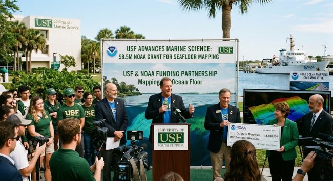
Quick Answer: The University of South Florida’s College of Marine Science in St. Petersburg won a five-year, $8.5 million NOAA cooperative agreement to continue its Center for Ocean Mapping and Innovative Technologies (COMIT). The funding adds AI and robotics to seafloor mapping and expands a program that uses local boaters to collect depth data.
What USF Received
The award is a five-year, $8.5 million cooperative agreement from NOAA’s Office of Coast Survey, renewing support for COMIT. The center first launched in 2020 with a $9 million NOAA award, which means federal investment in USF’s ocean mapping program now totals roughly $17.5 million.
USF announced the award on September 14, 2026.
Award Snapshot
| Item | Detail |
|---|---|
| Recipient | USF College of Marine Science |
| Program | COMIT |
| Funder | NOAA Office of Coast Survey |
| Amount | $8.5 million |
| Term | 5 years |
| Prior award | $9 million (2020) |
| Location | St. Petersburg |
| Director | Steven Murawski |
Why Seafloor Maps Matter to Tampa Bay Business
Accurate seafloor maps are essential for safe shipping, managing natural resources, and better predicting hurricane storm surge. For a region anchored by Port Tampa Bay, a large recreational boating economy and miles of storm-exposed coastline, those maps are economic infrastructure.
The seafloor also changes faster than many people realize. Murawski told WUSF that the 2024 storms shoved sand onto beaches and into inlets, creating navigation hazards. Outdated charts after a hurricane can slow commercial traffic, raise risk for boaters and complicate beach renourishment planning.
What the New Funding Will Do
Bringing AI Into Ocean Mapping
The biggest change is artificial intelligence. Faculty from the USF College of Engineering and the new Bellini College of Artificial Intelligence, Cybersecurity and Computing are joining marine scientists to apply AI and applied engineering to mapping and data processing.
Murawski expects the next five years to bring rapid gains in processing mapping data with AI and machine learning.
In the lab of engineering professor Xiaomin Lin, researchers install multimodal AI directly on robotic vehicles. That lets the vehicles interpret what they detect while still in the water and adjust the survey on the spot, instead of waiting for data to be analyzed onshore. Lin notes the ocean is a difficult environment to see in, with scattered light and noisy sonar returns, and a vehicle has to make its own decisions once it’s away from the ship.
Expanding “Crowd the Bay”
COMIT also runs Crowd the Bay, a program that recruits everyday boaters to collect seafloor data and keep Florida’s underwater maps current. According to WUSF, the new funding doubles USF’s capacity to receive depth measurements from residents by placing depth recorders on private boats.
Past participants have included the USGS St. Petersburg Coastal & Marine Science Center, Pinellas County Environmental Management, Eckerd College and private boaters. Eckerd College’s Search and Rescue team has been among the most active contributors.
COMIT’s Track Record
COMIT focuses on shallow, nearshore waters, which are especially hard and expensive to map with traditional sonar. Its methods have been adopted by researchers worldwide. The center has helped pioneer autonomous vehicles, crowdsourced data and public-private partnerships to keep mapping costs down.
NOAA’s Office of Coast Survey director, Rear Admiral Christiaan van Westendorp, praised COMIT for its “cutting-edge approaches” to mapping products tied to national ocean and coastal priorities. usf
How It Fits Florida’s Bigger Mapping Push
USF’s grant lands alongside the state’s own effort. Florida lawmakers put $100 million toward the five-year Florida Seafloor Mapping Initiative (FSMI) in 2021 to collect high-resolution underwater depth data along the coast.
The state program has mapped more than 75,500 square kilometers with LiDAR and more than 64,000 with sonar. Before it began, only about 25,600 square kilometers of Florida’s seafloor had been mapped. The data is expected to become publicly available in fall 2026, and it will feed the statewide vulnerability assessment and flood-risk modeling for coastal communities.
The two efforts complement each other: the state built a large baseline map, while USF’s crowdsourcing and AI work help keep that map current as storms reshape the bottom.
Frequently Asked Questions
How much did USF receive for seafloor mapping?
$8.5 million over five years from NOAA’s Office of Coast Survey.
What is COMIT?
COMIT is USF’s Center for Ocean Mapping and Innovative Technologies at the College of Marine Science in St. Petersburg. It researches new technologies and methods for mapping the seafloor.
Who leads the program?
Steven Murawski, a professor in the College of Marine Science, directs COMIT. Tom Frazer is dean of the college.
How can boaters help map Tampa Bay?
Through USF’s Crowd the Bay program, which places depth recorders on volunteer boats. Interested boaters can contact COMIT through the USF College of Marine Science.
Why do seafloor maps change after hurricanes?
Storms move large amounts of sand, building up beaches and filling inlets. That can create new shoals and navigation hazards.
Will the public get access to the data?
The state’s Florida Seafloor Mapping Initiative data is expected to be publicly available in fall 2026.
Brian’s Take
An $8.5 million research grant won’t move Tampa Bay’s GDP on its own, but this one deserves more attention from the business community than it will get. Seafloor maps sit underneath almost everything that makes the coastal economy work: port access, insurance pricing tied to storm surge models, beach renourishment budgets, marine construction, and a recreational boating industry that depends on safe channels.
The smart part of USF’s model is cost. Survey ships are expensive; volunteer boats with depth loggers and AI-equipped drones are not. Doubling crowdsourcing capacity turns local boaters into a low-cost, always-on mapping network that can update charts after each hurricane season rather than every few years.
There’s also a workforce story. Pairing marine science with the new Bellini College of AI puts St. Petersburg in a position to train people in a niche where hydrography, robotics and machine learning overlap. That’s the kind of specialized blue-economy talent that attracts marine tech companies and federal contracts. Tampa Bay businesses in marine services, engineering and geospatial data should be watching who comes out of this program.
Sources and Further Reading
- USF seafloor mapping initiative earns $8.5 million NOAA award — USF College of Marine Science
- NOAA Renews COMIT Funding to Push Seafloor Mapping Innovation — Environment Coastal & OffshoreFlorida Maps the Seafloor by Air and Sea — Esri
- Florida Seafloor Mapping Initiative Reached Major Milestone — West Orlando News
- Florida Seafloor Mapping Initiative — Florida GIO
About the Author